NASA Sea level projection tool

Published: Aug 12, 2021 by ISG Board

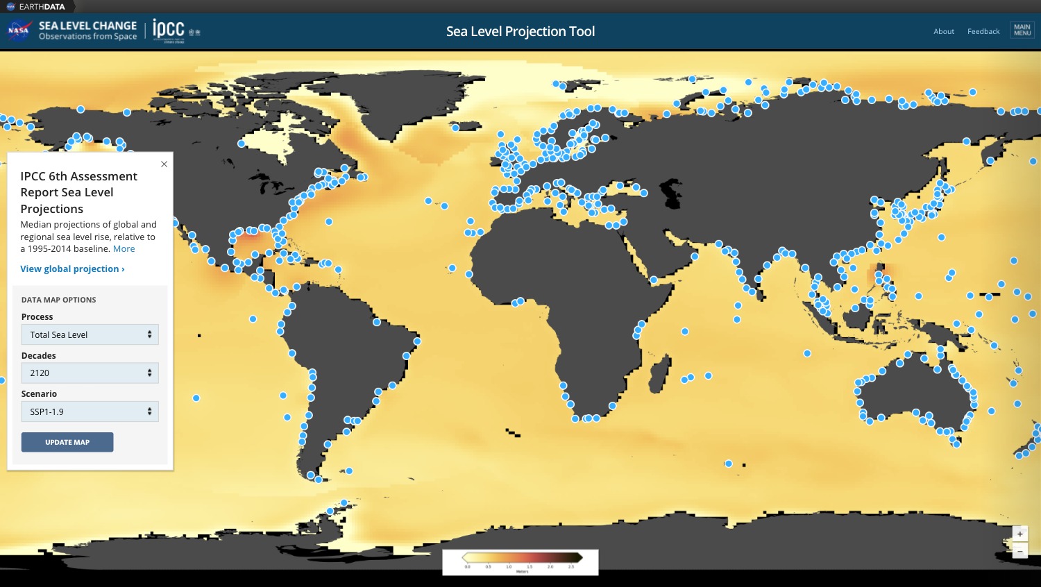
NASA has recently released an interactive webmapping tool to explore effect of global warming on the sea level rise and potential risks / damages associated.

“The NASA Sea Level Projection Tool allows users to visualize and download the sea level projection data from the IPCC 6th Assessment Report (AR6). The goal of this tool is to provide easy and improved access and visualization to the consensus projections found in the report. The target audience is intended to be broad, allowing a general audience and scientists alike to interact with the information contained in the AR6.”

To learn more about method and Digital Terrain Model source used for modeling, please refer to:

  • Fox-Kemper, B., H. T. Hewitt, C. Xiao, G. Aðalgeirsdóttir, S. S. Drijfhout, T. L. Edwards, N. R. Golledge, M. Hemer, R. E. Kopp, G. Krinner, A. Mix, D. Notz, S. Nowicki, I. S. Nurhati, L. Ruiz, J-B. Sallée, A. B. A. Slangen, Y. Yu, (2021). Ocean, Cryosphere and Sea Level Change. In: Climate Change 2021: The Physical Science Basis. Contribution of Working Group I to the Sixth Assessment Report of the Intergovernmental Panel on Climate Change [MassonDelmotte, V., P. Zhai, A. Pirani, S. L. Connors, C. Péan, S. Berger, N. Caud, Y. Chen, L. Goldfarb, M. I. Gomis, M. Huang, K. Leitzell, E. Lonnoy, J. B. R. Matthews, T. K. Maycock, T. Waterfield, O. Yelekçi, R. Yu and B. Zhou (eds.)]. Cambridge University Press. In Press.

story nasa dataset

Share

Latest Posts

Cover Design Contest for the Upcoming Book on Geomorphometry

Dear geomorphometry community,

We are pleased to invite submissions for a cover design contest for the second edition of the Geomorphometry book, to be published in 2026.

The submissions will be gathered in a poll, and the entire community will be able to vote for their favorite design.

If your design is selected, you will receive the appropriate credits, but would need to provide the necessary permissions to use the image.

You can submit your design by email before October 17th. Please ensure that the image is of at least 300 dpi resolution.

Get designing!

The editors,
Hannes Reuter
Carlos Grohmann
Vincent Lecours

Coffee Talk - Recent Research Progress in Geomorphometry in China

Recent Research Progress in Geomorphometry in China

Dr. Li-Yang Xiong
Nanjing Normal University, China

October 1st , 2025
8:00 MDT (UTC -6), 10:00 EDT (UTC -4), 11:00 BRT (UTC - 3), 15:00 BST (UTC +1), 16:00 CEST (UTC +2), 17:00 EEST (UTC +3), 22:00 CST (UTC +8)

Bio: Dr. Li-Yang Xiong is a professor at the School of Geographical Science, Nanjing Normal University (NNU), China. He is currently responsible for managing NNU’s research in Digital Terrain Model and Digital Terrain Analysis. His main research interests include AI based terrain modelling, loess terrain feature characterization, landform evolution modeling, paleotopography reconstruction and geomorphological process mining. His recent work involves deep learning-based DEM reconstruction, geomorphology-oriented digital terrain analysis, and value-added digital terrain applications for geoscience. He also serves as Associate Editor for the journal Earth Surface Processes and Landforms and as an Editorial Board Member for International Journal of Geographical Information Science.

Abstract: In this talk, I will present some recent research achievements related to terrain modelling theory, terrain analysis method and terrain application in China. This terrain modeling theory focused on how we understand terrain knowledge and integrate it into AI methods for terrain reconstruction. In term of the terrain analysis method, the mathematical vector operation we believe should be highlighted in the research of Geomorphometry, which is suitable for multi-source data structure by considering the directional property of terrain parameters. Actually, this directional property should be made a full consideration for process- oriented geographical modeling and simulation. Lastly, I will show some terrain applications towards different typical geographical areas in China as well as global scale application.

PHD position in Italy

Dear colleagues,

I’m grateful if you can circulate information on this PhD opportunity in Italy. The potential candidates can contact me (strevisani@iuav.it) for further information. Here the main elements of the position:

Research topics: Predicting and supporting benthic and pelagic biodiversity through geomorphometry and machine learning

Link to the call (Italian and English): https://www.unipa.it/didattica/dottorati/dottorato-xli/bando-di-accesso-ciclo-41/

Position code [BIODIV.OGS]

Research headquarters OGS Trieste and University of Palermo

Funded by OGS - Istituto Nazionale di Oceanografia e di Geofisica Sperimentale

Key dates: Deadline: 7th August 2025 - 14:59 (Italian time)