Boschoord case study

Published: Oct 20, 2009 by Tom Hengl

The case study “Boschoord” (3024 ha) is a small area located in the province of Drenthe, in the northern part of the Netherlands. The Boschoord area is part of the Drenthe Plateau which is underlain by boulder clay deposited by the second last (Saalien) ice sheet. This rather complex genesis created a fragmented landscape in which hydrological differences are strongly linked to this polycyclic landscape development. What makes this dataset especially interesting is that it is an area of low relief, but with distinct geomorphological classes that have been mapped with relatively high accuracy (Koomen and Maas, 2004). The elevations range from 3 to 10 m above the sea level, with a standard deviation of 1.54 m; changes in topography are difficult to notice even in the field. This data set is available only for collaborators. To receive a password to use the data, please contact the authors.

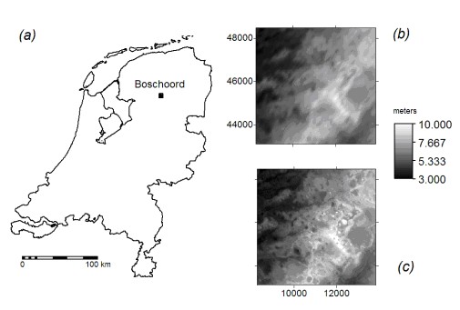
Fig: Location of the study area (a) and the two main DEM data sources used for analysis: DEM25TOPO – generated using ordinary kriging (b) and DEM25LIDAR (c).

Available layers:

- Elevation datasets – This includes the 5 m LiDAR DEM (surveyed in 2004), and a point dataset with 5010 measurements of heights (surveyed in 1960-69). Both datasets show elevations measured with a high precision (±10-20 cm).
- Geomorphological map (GKN50) – The map contains of 12 classes: Ground moraine (3L1), Low plains with ridges (3N3), Peat bog depressions (2R4), Cover sand undulated (3L5), Low plains/depressions without ridges (3N4), Low dunes + plains (3L8), Low plains/depressions without ridges (3N4), Cover sand undulated (3K14), Undulating ground moraines (3L1), Ground moraine (high) (3L2a), Low dunes + plains (3L9), Areas partially covered with cover sand (2M14), Low dunes (4K19), and Cover sand areas (2M13).
- Topographic data – Includes all roads and infrastructure, land use classes and similar features from the TOP10VECTOR basic topographic map of the Netherlands (1:5000 scale). This data is used only for orientation purposes.Grid definition:

ncols: 1110
nrows: 1081
xllcorner: 208297
yllcorner: 543057
cellsize: 5proj4:+proj=sterea +lat_0=52.15616055555555 +lon_0=5.38763888888889 +k=0.999908 +x_0=155000 +y_0=463000 +ellps=bessel +towgs84=565.237,50.0087,465.658,-0.406857,0.350733,-1.87035,4.0812 +units=m +no_defsLineage:

The 5020 field measurements of elevation (land survey) collected in the 1960s by the ‘Meetkundige Dienst Rijkswaterstaat’. This was used to generate the 25 m DEM25TOPO. The 5 m LiDAR-based DEM distributed by the Ministry of transportation and water management (measurements in cm). This dataset is also known as “Actueel Hoogtebestand Nederland” (AHN ) (van Heerd et al. 2008).

Data owner:Universiteit van Amsterdam
Reference:Semi-automated identification and extraction of geomorphological features using digital elevation data
Location: Boschoord Netherlands52° 53’ 55.7772” N,6° 13’ 41.2896” E
See map:Google Maps

dataset script

Share

Latest Posts

Cover Design Contest for the Upcoming Book on Geomorphometry

Dear geomorphometry community,

We are pleased to invite submissions for a cover design contest for the second edition of the Geomorphometry book, to be published in 2026.

The submissions will be gathered in a poll, and the entire community will be able to vote for their favorite design.

If your design is selected, you will receive the appropriate credits, but would need to provide the necessary permissions to use the image.

You can submit your design by email before October 17th. Please ensure that the image is of at least 300 dpi resolution.

Get designing!

The editors,
Hannes Reuter
Carlos Grohmann
Vincent Lecours

Coffee Talk - Recent Research Progress in Geomorphometry in China

Recent Research Progress in Geomorphometry in China

Dr. Li-Yang Xiong
Nanjing Normal University, China

October 1st , 2025
8:00 MDT (UTC -6), 10:00 EDT (UTC -4), 11:00 BRT (UTC - 3), 15:00 BST (UTC +1), 16:00 CEST (UTC +2), 17:00 EEST (UTC +3), 22:00 CST (UTC +8)

Recording available in our YouTube channel

Bio: Dr. Li-Yang Xiong is a professor at the School of Geographical Science, Nanjing Normal University (NNU), China. He is currently responsible for managing NNU’s research in Digital Terrain Model and Digital Terrain Analysis. His main research interests include AI based terrain modelling, loess terrain feature characterization, landform evolution modeling, paleotopography reconstruction and geomorphological process mining. His recent work involves deep learning-based DEM reconstruction, geomorphology-oriented digital terrain analysis, and value-added digital terrain applications for geoscience. He also serves as Associate Editor for the journal Earth Surface Processes and Landforms and as an Editorial Board Member for International Journal of Geographical Information Science.

Abstract: In this talk, I will present some recent research achievements related to terrain modelling theory, terrain analysis method and terrain application in China. This terrain modeling theory focused on how we understand terrain knowledge and integrate it into AI methods for terrain reconstruction. In term of the terrain analysis method, the mathematical vector operation we believe should be highlighted in the research of Geomorphometry, which is suitable for multi-source data structure by considering the directional property of terrain parameters. Actually, this directional property should be made a full consideration for process- oriented geographical modeling and simulation. Lastly, I will show some terrain applications towards different typical geographical areas in China as well as global scale application.

PHD position in Italy

Dear colleagues,

I’m grateful if you can circulate information on this PhD opportunity in Italy. The potential candidates can contact me (strevisani@iuav.it) for further information. Here the main elements of the position:

Research topics: Predicting and supporting benthic and pelagic biodiversity through geomorphometry and machine learning

Link to the call (Italian and English): https://www.unipa.it/didattica/dottorati/dottorato-xli/bando-di-accesso-ciclo-41/

Position code [BIODIV.OGS]

Research headquarters OGS Trieste and University of Palermo

Funded by OGS - Istituto Nazionale di Oceanografia e di Geofisica Sperimentale

Key dates: Deadline: 7th August 2025 - 14:59 (Italian time)