TanDEM-X evaluation for selected Brazilian sites

Published: Mar 12, 2018 by C.H. Grohmann

Github repository containing scripts and associated supplemental material (csv files, etc) for the paper:

Grohmann, C.H. 2018. Evaluation of TanDEM-X DEMs on selected Brazilian sites: comparison with SRTM, ASTER GDEM and ALOS AW3D30 Remote Sensing of Environment, 212C:121-133.
View article at publisher (paywalled): https://doi.org/10.1016/j.rse.2018.04.043
Open Access preprint (same content as article, different formatting): https://arxiv.org/abs/1709.05016

Link to GitHub repository: https://github.com/CarlosGrohmann/scripts_papers/tree/master/tdx_brazil

In the paper, a first assessment of the TanDEM-X DEMs over Brazilian territory is presented through a comparison with SRTM, ASTER GDEM and ALOS AW3D30 DEMs in seven study areas with distinct geomorphological contexts, vegetation coverage, and land use.

The analyzes were made using GRASS-GIS trough python scripts. Although the DEMs cannot be shared in GitHub (due to both space limitations and licensing of TanDEM-X), the scripts can be used as an educational resource.

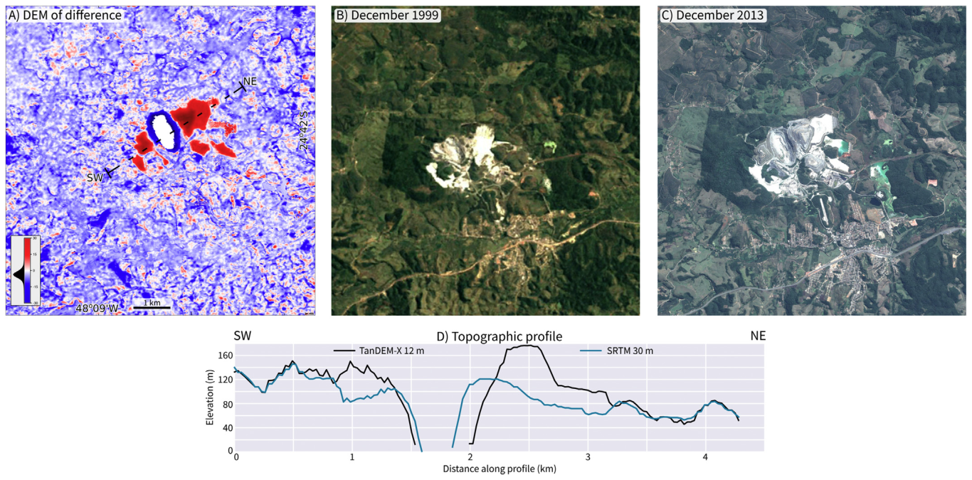
Difference between TDX and SRTM for a mining area in southeastern Brazil

TanDEM-X data was provided by the German Aerospace Centre (DLR) through an Announcement of Opportunity & Proposal Call (proposal DEM_GEOL0538).

This study was supported by Brazil’s National Council of Scientific and Technological Development, CNPq grant 307647/2015-3, the Sao Paulo Research Foundation (FAPESP) grant #2016/06628-0, and is co-funded by FAPESP (BIOTA #2012/50260-6, #2013/50297-0),NSF (DEB 1343578), and NASA.

dataset script tandem-x grass srtm

Share

Latest Posts

Cover Design Contest for the Upcoming Book on Geomorphometry

Dear geomorphometry community,

We are pleased to invite submissions for a cover design contest for the second edition of the Geomorphometry book, to be published in 2026.

The submissions will be gathered in a poll, and the entire community will be able to vote for their favorite design.

If your design is selected, you will receive the appropriate credits, but would need to provide the necessary permissions to use the image.

You can submit your design by email before October 17th. Please ensure that the image is of at least 300 dpi resolution.

Get designing!

The editors,
Hannes Reuter
Carlos Grohmann
Vincent Lecours

Coffee Talk - Recent Research Progress in Geomorphometry in China

Recent Research Progress in Geomorphometry in China

Dr. Li-Yang Xiong
Nanjing Normal University, China

October 1st , 2025
8:00 MDT (UTC -6), 10:00 EDT (UTC -4), 11:00 BRT (UTC - 3), 15:00 BST (UTC +1), 16:00 CEST (UTC +2), 17:00 EEST (UTC +3), 22:00 CST (UTC +8)

Recording available in our YouTube channel

Bio: Dr. Li-Yang Xiong is a professor at the School of Geographical Science, Nanjing Normal University (NNU), China. He is currently responsible for managing NNU’s research in Digital Terrain Model and Digital Terrain Analysis. His main research interests include AI based terrain modelling, loess terrain feature characterization, landform evolution modeling, paleotopography reconstruction and geomorphological process mining. His recent work involves deep learning-based DEM reconstruction, geomorphology-oriented digital terrain analysis, and value-added digital terrain applications for geoscience. He also serves as Associate Editor for the journal Earth Surface Processes and Landforms and as an Editorial Board Member for International Journal of Geographical Information Science.

Abstract: In this talk, I will present some recent research achievements related to terrain modelling theory, terrain analysis method and terrain application in China. This terrain modeling theory focused on how we understand terrain knowledge and integrate it into AI methods for terrain reconstruction. In term of the terrain analysis method, the mathematical vector operation we believe should be highlighted in the research of Geomorphometry, which is suitable for multi-source data structure by considering the directional property of terrain parameters. Actually, this directional property should be made a full consideration for process- oriented geographical modeling and simulation. Lastly, I will show some terrain applications towards different typical geographical areas in China as well as global scale application.

PHD position in Italy

Dear colleagues,

I’m grateful if you can circulate information on this PhD opportunity in Italy. The potential candidates can contact me (strevisani@iuav.it) for further information. Here the main elements of the position:

Research topics: Predicting and supporting benthic and pelagic biodiversity through geomorphometry and machine learning

Link to the call (Italian and English): https://www.unipa.it/didattica/dottorati/dottorato-xli/bando-di-accesso-ciclo-41/

Position code [BIODIV.OGS]

Research headquarters OGS Trieste and University of Palermo

Funded by OGS - Istituto Nazionale di Oceanografia e di Geofisica Sperimentale

Key dates: Deadline: 7th August 2025 - 14:59 (Italian time)