Published: Aug 1, 2023 by ISG Board
The Geomorphometry 2023 conference, held in Iași, Romania, brought together an extensive international community of researchers, practitioners, and specialists in digital terrain analysis and geomorphometry. A large scientific committee of leading experts from universities and research institutions worldwide supported the event. The program opened on Monday with registration and a welcome session, followed by the Geomorphometry Lifetime Achievement Award Lecture delivered by John Wilson, who addressed recent advances and challenges in the field. The first day continued with presentations on the evolution of Copernicus DEM, updates on FABDEM, comparative analyses between ALOS and COPDEM, and assessments of global elevation models for coastal zone mapping. Afternoon sessions explored new algorithms for flow direction, surface roughness experiments, bathymetric terrain classifications, daylight-based land-surface parameters, and landform detection methods. The day concluded with a guided city tour through Iași.
Tuesday was dedicated entirely to a field trip across northeastern Romania, offering participants direct exposure to geomorphologically significant landscapes. The itinerary included the Costești Geoarchaeosite, Cotnari Vineyard, the Dragoș Vodă Bison Reserve, and the medieval Neamț Fortress, combining scientific observation with cultural and historical context.
Wednesday’s sessions focused on modern computational approaches. Presentations addressed drone imagery processing, flood inundation modeling using SAR and DEM data, landslide susceptibility modeling, machine learning classification of geomorphometric segments, and deep learning methods for terrain super‑resolution. The afternoon focused on the CEOS DEMIX initiative, where speakers presented the structure, methodology, and results of the DEM Intercomparison Exercise. The “Wine Contest” method, which combines quantitative and qualitative criteria, was explained, along with demonstrations of the DEMIX Jupyter notebook and discussions on extending the DEMIX database using MICRODEM. The day ended with an audience panel discussion.
Thursday began with a keynote lecture by Jozef Minár on physics‑based geomorphometry, followed by sessions on gully mapping using Sentinel‑2 imagery, glacial cirque classification, and methodological considerations in defining study areas. Additional presentations addressed functional quality assessment of global DEMs, collaborative data infrastructures for DEM control, and innovative UAV‑based 3D cave modeling. The afternoon and evening were largely occupied by the ISG Business Meeting, and concluded with a conference dinner at the University House.
Friday was dedicated to hands‑on workshops. Serge Riazanoff led sessions on the DEMIX tools, including VtWeb and the DEMIX Operations Portal, demonstrating how to select DEM versions, visualize them, apply processing, compare datasets, and compute evaluation criteria. Additional workshops covered DEM4S2, explaining how to retrieve DEMs used for Sentinel‑2 orthorectification. John Lindsay led extensive training on Whitebox tools throughout the afternoon, giving participants hands-on experience with terrain analysis workflows. The day concluded with an informal city tour.
The conference also hosted a dedicated DEMIX workshop, presenting the objectives and structure of the DEM Intercomparison Exercise. DEMIX aims to compare global DEMs such as SRTM, ASTER GDEM, ALOS World‑3D, NASADEM, COP‑DEM, and FABDEM, enabling users to select the most suitable model for their region of interest. The initiative evaluates DEMs using criteria tested across multiple areas and interpreted through the “Wine contest” approach, combining quantitative and qualitative assessments. The workshop invited participants to engage with the project and access its tools and services.
Overall, Geomorphometry 2023 provided a comprehensive platform for scientific exchange, methodological innovation, and community engagement. Through its combination of lectures, technical sessions, field activities, and hands-on workshops, the conference strengthened international collaboration and advanced understanding of digital terrain modeling, geomorphometric analysis, and global DEM benchmarking.
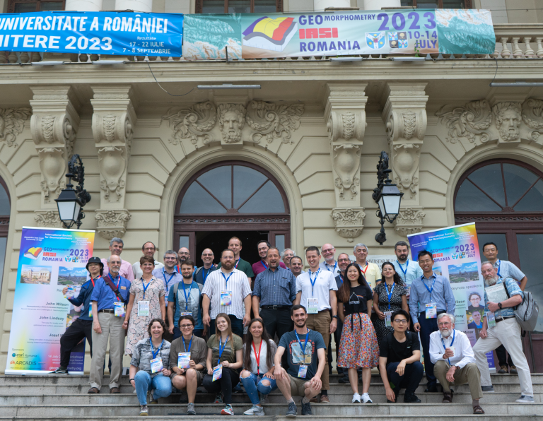
Happy faces from all around the world