ANADEM: A Digital Terrain Model for South America

Published: Jul 15, 2025 by C.H. Grohmann

There is a new paper (open access) describing a Machine Learning-based DTM for South America:

Laipelt L., Andrade B.C., Collischonn W., Teixeira A.A., Paiva R.C.D., Ruhoff A., 2024. ANADEM: A Digital Terrain Model for South America. Remote Sensing 16(13):2321. https://doi.org/10.3390/rs16132321

Paper abstract:
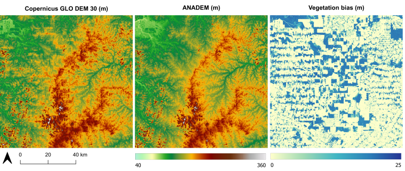
Digital elevation models (DEMs) have a wide range of applications and play a crucial role in many studies. Numerous public DEMs, frequently acquired using radar and optical satellite imagery, are currently available; however, DEM datasets tend to exhibit elevation values influenced by vegetation height and coverage, compromising the accuracy of models in representing terrain elevation. In this study, we developed a digital terrain model for South America using a novel methodology to remove vegetation bias in the Copernicus DEM GLO-30 (COPDEM) model using machine learning, Global Ecosystem Dynamics Investigation (GEDI) elevation data, and multispectral remote sensing products. Our results indicate considerable improvements compared to COPDEM in representing terrain elevation, reducing average errors (BIAS) from 9.6 m to 1.5 m. Furthermore, we evaluated our product (ANADEM) by comparison with other global DEMs, obtaining more accurate results for different conditions of vegetation fraction cover and land use. As a publicly available and open-source dataset, ANADEM will play a crucial role in advancing studies that demand accurate terrain elevation representations at large scales.

Data Access
ANADEM can be downloaded at https://hge-iph.github.io/anadem/ or accessed directly in GoogleEarth Engine (see instructions on the project link).

story srtm aster alos fabdem nasadem copdem copernicus demix dataset

Share

Latest Posts

Cover Design Contest for the Upcoming Book on Geomorphometry

Dear geomorphometry community,

We are pleased to invite submissions for a cover design contest for the second edition of the Geomorphometry book, to be published in 2026.

The submissions will be gathered in a poll, and the entire community will be able to vote for their favorite design.

If your design is selected, you will receive the appropriate credits, but would need to provide the necessary permissions to use the image.

You can submit your design by email before October 17th. Please ensure that the image is of at least 300 dpi resolution.

Get designing!

The editors,
Hannes Reuter
Carlos Grohmann
Vincent Lecours

Coffee Talk - Recent Research Progress in Geomorphometry in China

Recent Research Progress in Geomorphometry in China

Dr. Li-Yang Xiong
Nanjing Normal University, China

October 1st , 2025
8:00 MDT (UTC -6), 10:00 EDT (UTC -4), 11:00 BRT (UTC - 3), 15:00 BST (UTC +1), 16:00 CEST (UTC +2), 17:00 EEST (UTC +3), 22:00 CST (UTC +8)

Recording available in our YouTube channel

Bio: Dr. Li-Yang Xiong is a professor at the School of Geographical Science, Nanjing Normal University (NNU), China. He is currently responsible for managing NNU’s research in Digital Terrain Model and Digital Terrain Analysis. His main research interests include AI based terrain modelling, loess terrain feature characterization, landform evolution modeling, paleotopography reconstruction and geomorphological process mining. His recent work involves deep learning-based DEM reconstruction, geomorphology-oriented digital terrain analysis, and value-added digital terrain applications for geoscience. He also serves as Associate Editor for the journal Earth Surface Processes and Landforms and as an Editorial Board Member for International Journal of Geographical Information Science.

Abstract: In this talk, I will present some recent research achievements related to terrain modelling theory, terrain analysis method and terrain application in China. This terrain modeling theory focused on how we understand terrain knowledge and integrate it into AI methods for terrain reconstruction. In term of the terrain analysis method, the mathematical vector operation we believe should be highlighted in the research of Geomorphometry, which is suitable for multi-source data structure by considering the directional property of terrain parameters. Actually, this directional property should be made a full consideration for process- oriented geographical modeling and simulation. Lastly, I will show some terrain applications towards different typical geographical areas in China as well as global scale application.

PHD position in Italy

Dear colleagues,

I’m grateful if you can circulate information on this PhD opportunity in Italy. The potential candidates can contact me (strevisani@iuav.it) for further information. Here the main elements of the position:

Research topics: Predicting and supporting benthic and pelagic biodiversity through geomorphometry and machine learning

Link to the call (Italian and English): https://www.unipa.it/didattica/dottorati/dottorato-xli/bando-di-accesso-ciclo-41/

Position code [BIODIV.OGS]

Research headquarters OGS Trieste and University of Palermo

Funded by OGS - Istituto Nazionale di Oceanografia e di Geofisica Sperimentale

Key dates: Deadline: 7th August 2025 - 14:59 (Italian time)