Zlatibor

Published: Aug 19, 2009 by Tom Hengl

The case study area ‘Zlatibor’ is located in the South-western part of Serbia (centred at 43°43’44.6’‘N and 19°42’37.8’‘E). The area is mainly hilly plateau, with the exception of the north-east part where the slopes are much steeper. Elevations range from 850 m to a maximum of 1174 m; the total size of the area is 13.5 square kilometers.

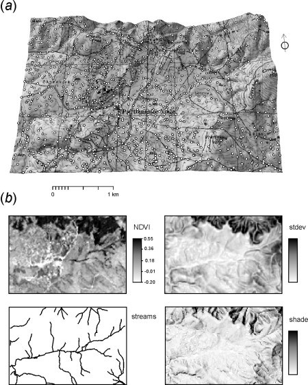
Study area Zlatibor: (a) perspective view on the area (1:25,000 topo-map) and location of 1020 error assessment points, (b) a preview of the auxiliary predictors used for the geostatistical modeling

Available layers:

- elevations.txt - a set of 2051 height measurements used for generation of DEMs;
- control.txt - a set of 1020 very precise spot heights used for error assessment;
- dem30.asc - the original topo-map DEM at 30 m resolution;
- SRTMDEM.asc - 3 arcsec (90 m) SRTM DEM;

Grid definition:

ncols: 150
nrows: 100
xllcorner: 7394249
yllcorner: 4841999
cellsize: 30 m

proj4:+proj=tmerc +lat_0=0 +lon_0=21 +k=0.9999 +x_0=7500000 +y_0=0 +ellps=bessel +towgs84=574.027,170.175,401.545,4.88786,-0.66524,-13.24673,0.99999311067 +units=m

Lineage:

The original topo-map DEM was produced by digitizing contour layers from two adjacent sheets of the 1:5000 topographic maps with contour interval of 5 m. Two sheets were scanned by ANATech Evolution scanner with 400 DPI resolution, then georeferenced to the Gauss-Krüger coordinate system (7th zone) and converted to a point map using a semi-automated digitalization of contour lines (I/GEOVEC, Intergraph program module). The faults obtained during automated digitalization were removed by 3D editing of contour lines. The final DEM was produced using the ArcGIS 3D analyst: first a TIN was produced, which was then converted to a regular grid of 30~m resolution. This will be referred to as the topo-DEM in further text. The original points extracted from the topo-map (51,847 points) were sub-sampled (for computational efficiency) to 2051 points.

A set of 1020 photogrammetric control points was provided with the help of the Geodetic governmental authority of Serbia. These were obtained throughout the orthophoto map production of the scale 1:1000 for local municipality. Aerial images were obtained using the RMK 21/23 analog camera with calibrated focal length f=207.96 mm. The average flying altitude was 1040 m. A stereoscopic model was produced using the WILD A10 analog stereo-restitution instrument and MapSoft2000 program package. The land-surface points were measured manually from the stereoscopic model with average lag of 15 m. This gave a total number of 46,021 points that were sub-sampled to 1020 points for faster processing. The estimated height accuracy of control points is 15 cm which allows us to use it as ground truth for the topo-DEM.

Data owner: Geodetic governmental authority of Serbia
Reference: Geostatistical modelling of topography using auxiliary maps
Location: Zlatibor, Serbia
43° 43’ 0.0012” N,19° 41’ 60” E See map: Google Maps


Attachment:

Download

dataset script

Share

Latest Posts

Cover Design Contest for the Upcoming Book on Geomorphometry

Dear geomorphometry community,

We are pleased to invite submissions for a cover design contest for the second edition of the Geomorphometry book, to be published in 2026.

The submissions will be gathered in a poll, and the entire community will be able to vote for their favorite design.

If your design is selected, you will receive the appropriate credits, but would need to provide the necessary permissions to use the image.

You can submit your design by email before October 17th. Please ensure that the image is of at least 300 dpi resolution.

Get designing!

The editors,
Hannes Reuter
Carlos Grohmann
Vincent Lecours

Coffee Talk - Recent Research Progress in Geomorphometry in China

Recent Research Progress in Geomorphometry in China

Dr. Li-Yang Xiong
Nanjing Normal University, China

October 1st , 2025
8:00 MDT (UTC -6), 10:00 EDT (UTC -4), 11:00 BRT (UTC - 3), 15:00 BST (UTC +1), 16:00 CEST (UTC +2), 17:00 EEST (UTC +3), 22:00 CST (UTC +8)

Recording available in our YouTube channel

Bio: Dr. Li-Yang Xiong is a professor at the School of Geographical Science, Nanjing Normal University (NNU), China. He is currently responsible for managing NNU’s research in Digital Terrain Model and Digital Terrain Analysis. His main research interests include AI based terrain modelling, loess terrain feature characterization, landform evolution modeling, paleotopography reconstruction and geomorphological process mining. His recent work involves deep learning-based DEM reconstruction, geomorphology-oriented digital terrain analysis, and value-added digital terrain applications for geoscience. He also serves as Associate Editor for the journal Earth Surface Processes and Landforms and as an Editorial Board Member for International Journal of Geographical Information Science.

Abstract: In this talk, I will present some recent research achievements related to terrain modelling theory, terrain analysis method and terrain application in China. This terrain modeling theory focused on how we understand terrain knowledge and integrate it into AI methods for terrain reconstruction. In term of the terrain analysis method, the mathematical vector operation we believe should be highlighted in the research of Geomorphometry, which is suitable for multi-source data structure by considering the directional property of terrain parameters. Actually, this directional property should be made a full consideration for process- oriented geographical modeling and simulation. Lastly, I will show some terrain applications towards different typical geographical areas in China as well as global scale application.

PHD position in Italy

Dear colleagues,

I’m grateful if you can circulate information on this PhD opportunity in Italy. The potential candidates can contact me (strevisani@iuav.it) for further information. Here the main elements of the position:

Research topics: Predicting and supporting benthic and pelagic biodiversity through geomorphometry and machine learning

Link to the call (Italian and English): https://www.unipa.it/didattica/dottorati/dottorato-xli/bando-di-accesso-ciclo-41/

Position code [BIODIV.OGS]

Research headquarters OGS Trieste and University of Palermo

Funded by OGS - Istituto Nazionale di Oceanografia e di Geofisica Sperimentale

Key dates: Deadline: 7th August 2025 - 14:59 (Italian time)