Blog

Digital Elevation Models (DEMs): Terminology and Definitions

There is a new paper on DEM terminology and definitions (open access):

Guth, P.L., Niekerk, A.V., Grohmann, C.H., Muller, J.-P., Hawker, L., Florinsky, I.V., Gesch, D., Reuter, H.I., Herrera-Cruz, V., Riazanoff, S., Lópéz-Vázquez, C., Carabajal, C.C., Albinet, C., Strobl, P., 2021 - Digital Elevation Models: Terminology and Definitions. Remote Sensing, 13(18):3581. https://doi.org/10.3390/rs13183581

The paper is the first major contribution of the DEMIX project (DEM Intercomparison EXercise). The idea is to “consolidate terminology and definitions of key concepts to facilitate a common understanding among the growing community of DEM users, who do not necessarily share the same background”.

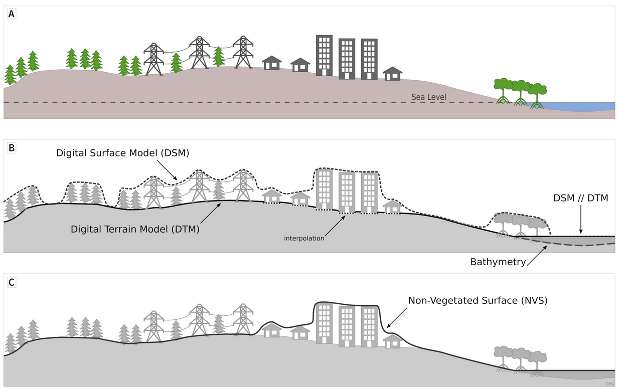
Scheme showing the surfaces represented by a DSM, a DTM, and a NVS (Guth et al., 2021)

Geomorphometry 2021 - Programme

Scientific Program

Topics

  • Use of Digital Elevation, Terrain and Surface Models
  • High resolution data collected with LiDAR, photogrammetry and satellite imagery
  • Automated surface analysis with machine learning and new algorithms
  • Measurements and simulations Earth surface changes
  • 3D and 4D dynamics of Earth surface
  • Morphometric techniques for climate change studies
  • Modeling extreme processes and natural hazards on the Earth surface
  • Marine Geomorphometry and bathymetry data
  • Geomorphometry for urban areas and cultural heritage
  • Planetary morphometry
  • Professional and industrial applications of Geomorphometry

SEPTEMBER 13: USE OF DIGITAL ELEVATION, TERRAIN AND SURFACE MODELS

10.00 Opening connections
10.15 Conference opening
10.30-10.45 Jozef Minár, Marián Jenčo and Ian S. Evans
What does land surface curvature really mean?
video
10.45-11.00 Cheng-Zhi Qin, Peng Liang and A-Xing Zhu
Two case-based classification strategies of automatically selecting terrain covariates for building geographic variable-environment relationship
presentation
video
11.00-11.15 Fran Domazetović, Ante Šiljeg and Ivan Marić
Guidelines for optimization of terrestrial laser scanning surveys over gully erosion affected areas
presentation
video
11.15-11.30 Alexey Victorov, Olga Trapeznikova and Timofey Orlov
Probabilistic behavior modeling of morphometric parameters for thermokarst plains with fluvial erosion in Cryolithozone
presentation
video
11.30-11.45 Break time
11.45-12.15 Keynote talk: Marco Cavalli, Stefano Crema and Lorenzo Marchi
Sediment connectivity assessment through a geomorphometric approach: review of recent applications
presentation
video
12.15-12.30 John Gallant
The surface stream function: representing flow topology with numbers
video
12.30-12.45 John Gallant
The D8 implementation of the surface stream
video
12.45-13.00 Discussion and Conclusion
13.00-14.00 Lunch time
14.00-14.15 Marina Metes, Kristina Hopkins, Labeeb Ahmed, Sam Lamont, Peter Claggett and Greg Noe
Mapping stream and floodplain geomorphic characteristics with the Floodplain and Channel Evaluation Tool (FACET) in the Mid-Atlantic Region, United States
presentation
video
14.15-14.30 Adeyemi Olusola
Lithology and channel network initiation and orientation: a case study of upper Ogun River Basin, Soyhwestern Nigeria
presentation
video
14.30-14.45 Priyank Patel, Sayoni Mondal and Rajarshi Dasgupta
Morphometric and channel erosivity analysis of lateritic gully catchments using high resolution DTM and repeat survey Structure-from-Motion datasets
published as full paper in Transactions in GIS
presentation
14.45-15.00 Francesco Bucci, Michele Santangelo, Francesco Mirabella, Andrea Mazzoni and Mauro Cardinali
Drainage inversion revealed by geomorphometric analysis of fluvial terraces
presentation
video
15.00-15.15 Break time
15.15-15.30 Mihai Niculita
Burial mound detection using geomorphometry and statistical methods: pixels versus objects
presentation
video
15.30-15.45 Richard Feciskanin and Jozef Minár
An optimization of triangular network and its use in DEM generalization for the land surface segmentation
published as full paper in Transactions in GIS
presentation
video
15.45-16.00 Vincent Lecours and Michael Espriella
Can multiscale roughness help computer-assisted identification of coastal habitats in Florida?
presentation
video
16.00-16.15 Charles Holderman, Steve Kopp and Nawajish Noman
A New Analytic Framework and Notebook for Terrain Analysis
presentation
video
16.30-16.45 Discussion and Conclusion

SEPTEMBER 14 DYNAMICS OF EARTH SURFACE: AUTOMATED SURFACE ANALYSIS AND MODELIZATION

10.00: Opening connections
10.30-10.45 Peter Guth
Using high-resolution lidar point clouds to evaluate 1-3 arc second global digital elevation models
presentation
video
10.45-11.00 Tera Geoffroy and Peter Guth
Using high-resolution ICESat-2 point clouds to evaluate 1-3 arc second global digital elevation models
published as full paper in Transactions in GIS
presentation
video
11.00-11.15 Daniele Pinton, Alberto Canestrellli, Christine Angelini, Benjamin Wilkinson, Peter Ifju and Andrew Ortega
Estimating the spatial distribution of vegetation height and ground level elevation in a mesotidal salt marsh from UAV LiDAR derived point cloud
published as full paper in Earth Surface Processes and Landforms
presentation
video
11.15-11.30 Guanghui Hu, Liyang Xiong and Guoan Tang
Mathematical vector framework for land surface curvature calculation from triangulated irregular network
video
11.30-11.45 Break time
11:45-11:50 Announcement of Lifetime Achievement Award
video
11.50-12.20 Keynote talk: Michael Hutchinson
Reflections on adding the Z dimension to earth system analysis
presentation
video
12.20-12.35 Sebastiano Trevisani
Geomorphometric features selection based on intrinsic dimension estimation
presentation
video
12.35-12.50 Kacper Jancewicz, Piotr Migoń, WioletaPorębna and Milena Różycka
High-resolution geomorphometry – a tool for better understanding the genesis and contemporary processes in erosional sandstone landscapes
presentation
video
12.50-13.00 Discussion and Conclusion
13.00-14.00 Lunch time
14.00-14.15 Tomislav Hengl and Leandro Parente
Continental-scale Digital Terrain Model for EU based on Ensemble Machine Learning
video
14.15-14.30 Gaurav Sinha and Samantha Arundel
Automated Extraction of Areal Extents For GNIS Summit Features Using the Eminence-Core Method
presentation
video
14.30-14.45 Olga Ishalina, Dmitrii Bliakharskii and Igor Florinsky
Detection of crevasses using high-resolution digital elevation models: Comparison of geomorphometric modeling and texture analysis
presentation
published as full paper in Transactions in GIS
14.45-15.00 Carlos Grohmann, Guilherme Garcia, Alynne Affonso and Rafael Albuquerque
Coastal dune modelling from airborne LiDAR, terrestrial LiDAR and Structure from Motion–Multi View Stereo
published as https://doi.org/10.1016/j.cageo.2020.104569
published as full paper in Computers & Geosciences
presentation
video
15.00-15.15 Break time
15.15-15.30 Bartłomiej Szypuła
DEM from topographic maps - as good as DEM from LiDAR?
presentation
video
15.30-15.45 Anna Dedkova,Igor Florinsky and Nikolay Djuzhev
Analysis of topography of silicon wafers and wafer-based structures by geomorphometric modeling
video
15.45-16.00 Peter L. Guth and Morgan E. Kane
Evaluation of slopes calculated from TanDEM-X digital elevation models at 3 spatial resolutions
video
16.00-16.15 Ivan Marić, Ante Šiljeg, Fran Domazetović and Neven Cukrov
A framework for using handheld 3D surface scanners in quantifying the volumetric tufa growth
presentation
16.15-16.30 Ante Šiljeg, Vlatko Roland, Lovre Panđa, Ivan Marić, Fran Domazetović, Silvija Šiljeg and Rina Milošević
Development of the new methodological framework for multiscale modeling of urban pluvial flooding
presentation
video
16.30-16.45 Discussion and conclusion

SEPTEMBER 15 MODELING GEOMORPHOLOGICAL PROCESSES

10.00: Opening connections  
10.15: Conference opening  
10.30-10.45 Andrei Dornik, Lucian Drăguț, Marinela Adriana Chețan, Takashi Oguchi, Yuichi Hayakawa and Mihai Micu
Towards a consistent set of land-surface variables for landslide modelling
presentation
video
10.45-11.00 Mihai Niculita
Landslide topographic signature prediction using segmentation of roughness and Random Forest
video
11.00-11.15 Stefan Steger
The role of pre-landslide morphology in statistical modelling of landslide-prone areas
presentation
published as full paper in Geomorphology
11.15-11.30 Mio Kasai
Incorporating ground cracks in the estimation of post-seismic landslide susceptibility
published as full paper in Transactions in GIS
presentation
video
11.30-11.45 Break time
11.45-12.15 Igor Florinsky, Sergey Filippov and Alexander Govorov
3D marine geomorphometry for the Arctic Ocean
video
12.15-12.30 Margaret Dolan, Lilja Bjarnadóttir, Terje Thorsnes, Markus Diesing and Shyam Chand
Geomorphometry in the deep Norwegian Sea
presentation
video
12.30-12.45 Queralt Guerrero, Ariadna Salabarnada, Amadeu Deu and Marcelo Devincenzi
Marine geophysical investigations for offshore wind farms and submarine interconnection cables
presentation
video
12.45-13.30 Meeting of the International Society for Geomorphometry. Everybody is welcome to attend
13.00-14.00 Lunch time
14.00-14.15 Ivica Milevski, Marjan Temovski, Balazs Madarasz, Zoltan Kern and Zsofia Ruszkiczay-Rudiger
Geomorphometry of the cirques of Shar Mountain
presentation
video
14.15-14.30 Ivica Milevski, Bojana Aleksova and Sonja Lepitkova
Geomorphometric characteristics of the high mountains in North Macedonia
presentation
video
14.30-14.45 Ian Sylvester Evans, Nicholas J. Cox,Mihai Niculita and David Milledge
Hypsoclinometric evidence of the degree of modification of mountains by glacial erosion
presentation
video
14.45-15.00 Simone Tarquini, Massimiliano Favalli, Melissa Pfeffer, Mattia De’ Michieli Vitturi, Sara Barsotti and Gro Pedersen
Assessing the impact of lava flows during the unrest of Svartsengi volcano in the Reykjaness peninsula, Iceland
15.15-15.30 Giuseppe Amatulli, Tushar Sethi, Longzhu Shen, Jaime Ricardo, Garcia-Márquez, Jens Kiesel and Sami Domisch
A new and extendable global watershed and stream network delineation using GRASS-GIS
presentation
video
15.30-15.45 Atrayee Biswas, Sunando Bandyopadhyay and Abhijit Chakraborty
Characterizing Gully Morphology using Structure-from-Motion (SfM) in Garhbeta Badlands, West Bengal, India
video
15.45-16.00 Badal Pokharel, Massimiliano Alvioli and Samsung Lim
Relevance of morphometric parameters and completeness of inventories in susceptibility modelling of earthquake-induced landslides
published as full paper in Scientific Reports
presentation
video
16.00-16.15 Massimiliano Alvioli, Michele Santangelo, Federica Fiorucci, Mauro Cardinali, Ivan Marchesini, Paola Reichenbach and Mauro Rossi
A data-driven method for assessing the probability for terrain grid cells of initiating rockfalls on a large area
published as full paper in Engineering Geology
presentation
video
16.15-16.30 Nada Ait Ayad, Adnane Habib, Khalid Elkhalidi, Abdeloihab Choukri and Abdelmounim Charif
Geomorphometric Analysis for Mapping Platforms of the Mazagan Corridor, Morocco
16:30-16:45 Announcement of best paper and best student paper awards recipients
  Best student paper award
  Daniele Pinton, Alberto Canestrellli, Christine Angelini, Benjamin Wilkinson, Peter Ifju and Andrew Ortega
Estimating the spatial distribution of vegetation height and ground level elevation in a mesotidal salt marsh from UAV LiDAR derived point cloud
published as full paper in Earth Surface Processes and Landforms
presentation
video
  Best paper award #1
  Michael Hutchinson
Reflections on adding the Z dimension to earth system analysis
presentation
video
  Best paper award #2
  Massimiliano Alvioli, Michele Santangelo, Federica Fiorucci, Mauro Cardinali, Ivan Marchesini, Paola Reichenbach and Mauro Rossi
A data-driven method for assessing the probability for terrain grid cells of initiating rockfalls on a large area
published as full paper in Engineering Geology
presentation
video
16.30-17.00 Discussion and closing remaks

Digital Elevation Model Intercomparison eXperiment (DEMIX) working group

The Digital Elevation Model Intercomparison eXperiment (DEMIX) working group is working to standardize DEM terminology, and evaluate the available global 1 arc second DEMs. They published a paper setting out their goals this summer.

10 minute movie: DEMIX – The Digital Elevation Model Intercomparison EXperiment

NASA Sea level projection tool

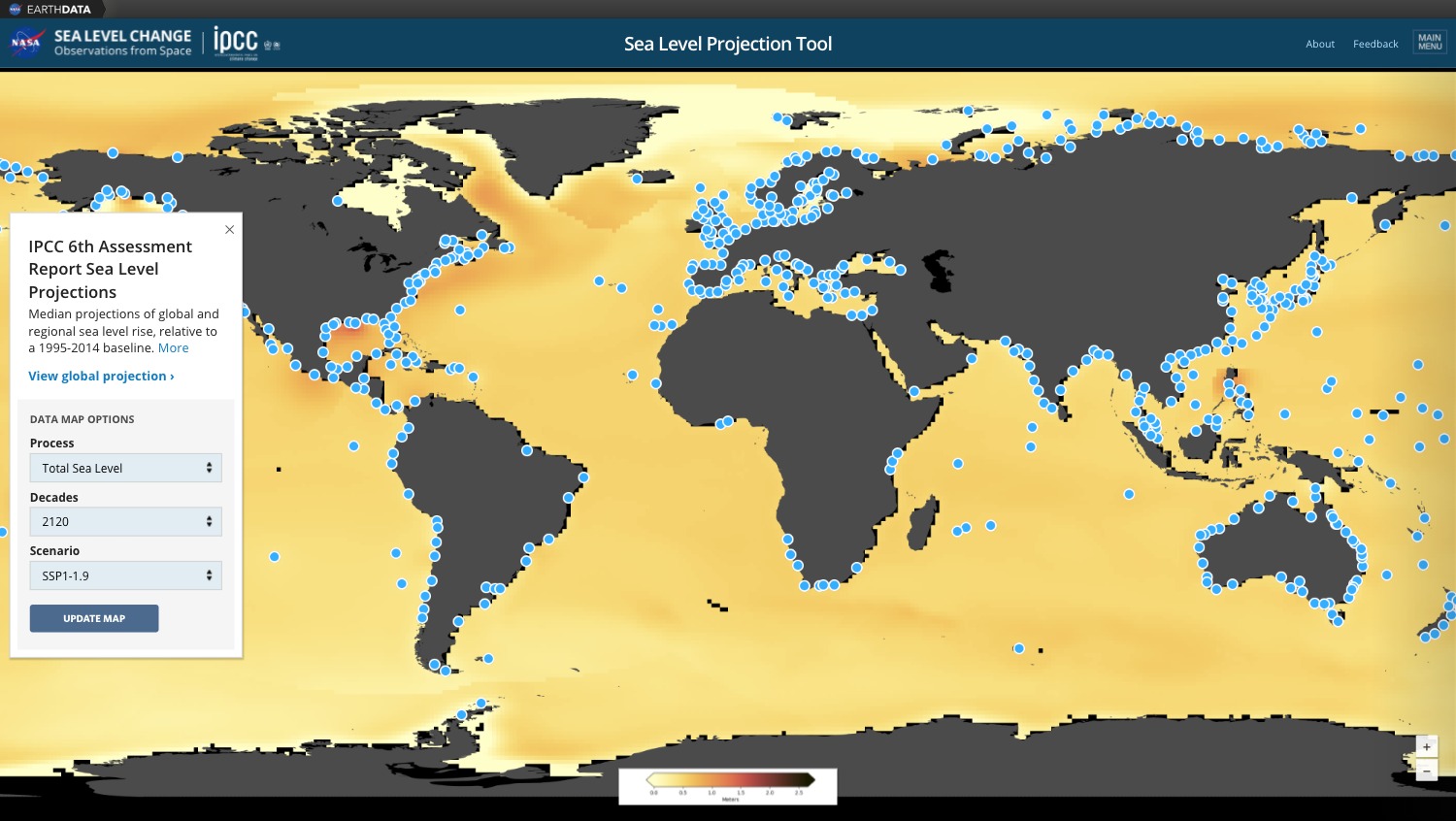
NASA has recently released an interactive webmapping tool to explore effect of global warming on the sea level rise and potential risks / damages associated.

“The NASA Sea Level Projection Tool allows users to visualize and download the sea level projection data from the IPCC 6th Assessment Report (AR6). The goal of this tool is to provide easy and improved access and visualization to the consensus projections found in the report. The target audience is intended to be broad, allowing a general audience and scientists alike to interact with the information contained in the AR6.”

To learn more about method and Digital Terrain Model source used for modeling, please refer to:

  • Fox-Kemper, B., H. T. Hewitt, C. Xiao, G. Aðalgeirsdóttir, S. S. Drijfhout, T. L. Edwards, N. R. Golledge, M. Hemer, R. E. Kopp, G. Krinner, A. Mix, D. Notz, S. Nowicki, I. S. Nurhati, L. Ruiz, J-B. Sallée, A. B. A. Slangen, Y. Yu, (2021). Ocean, Cryosphere and Sea Level Change. In: Climate Change 2021: The Physical Science Basis. Contribution of Working Group I to the Sixth Assessment Report of the Intergovernmental Panel on Climate Change [MassonDelmotte, V., P. Zhai, A. Pirani, S. L. Connors, C. Péan, S. Berger, N. Caud, Y. Chen, L. Goldfarb, M. I. Gomis, M. Huang, K. Leitzell, E. Lonnoy, J. B. R. Matthews, T. K. Maycock, T. Waterfield, O. Yelekçi, R. Yu and B. Zhou (eds.)]. Cambridge University Press. In Press.

Copernicus Digital Elevation Model (DEM) as Open Data on Amazon AWS and Sentinel-Hub

European Space Agency (ESA) has recently made available two global Digital Surface Models:

  • GLO-30: the 30-m spatial resolution DSM,
  • GLO-90: the 90-m spatial resolution DSM,

Both are available for download from cdsdata.copernicus.eu on a free basis for the general public under the terms and conditions of the Licence found here.

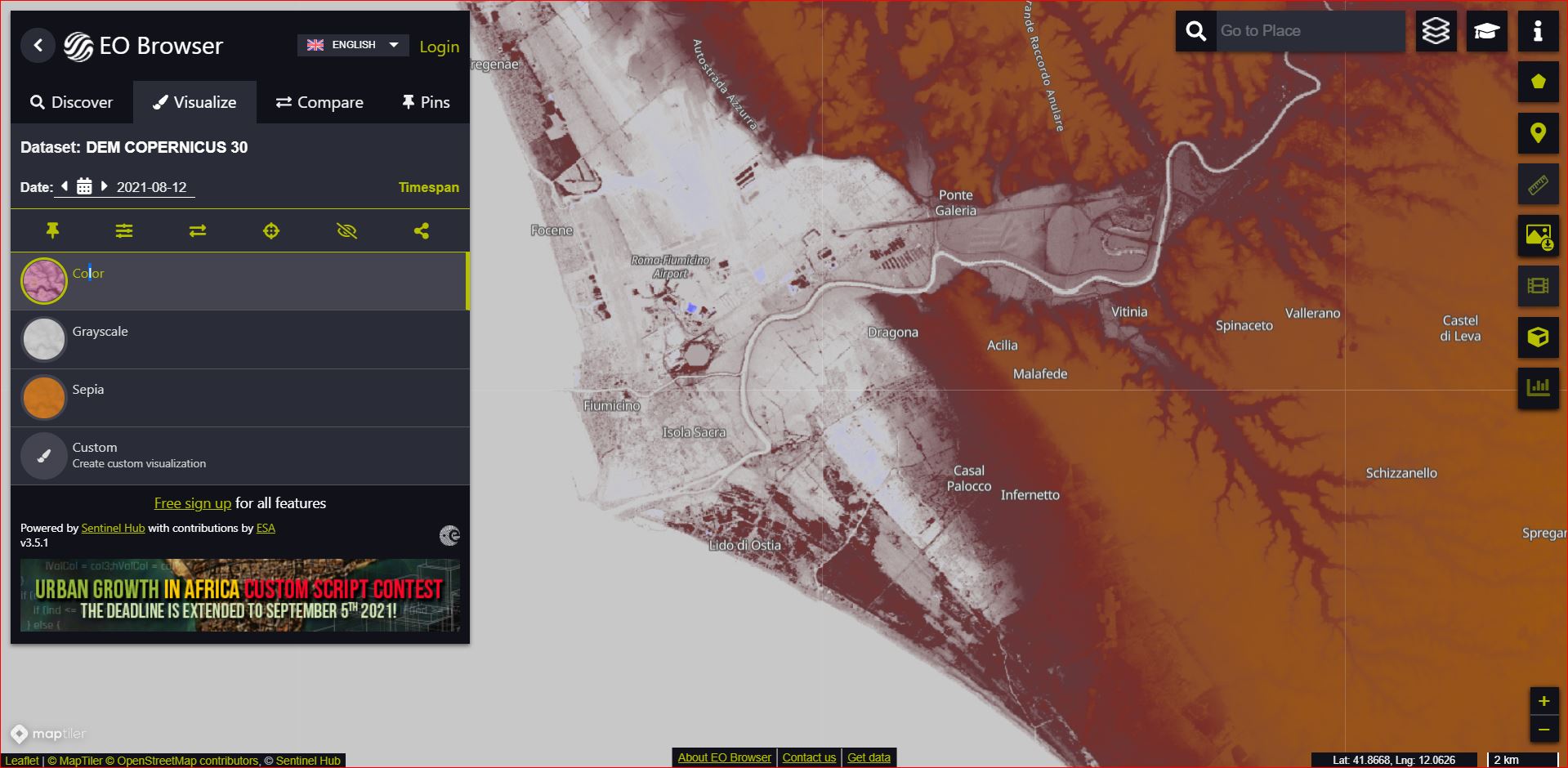
A copy of the GLO-30 and GLO-90 is now also available as Cloud Optimized GeoTIFFs from the Amazon AWS public data repository. The visualization shown above is from the sentinel-hub.com.

To learn more about the GLO-30 and it’s accuracy and production, refer to this article.

Latest Posts

Whitebox Workflows Next Gen released

Whitebox Workflows Next Gen, a complete rewrite of the Whitebox geospatial analysis platform, is now publicly available for Python, R, and QGIS.

Built from the ground up in pure Rust, Whitebox Next Gen provides more than 700 geospatial analysis tools for geomorphometry, terrain analysis, spatial hydrology, LiDAR processing, remote sensing, vector GIS, and spatial statistics. All three interfaces run on the same high-performance backend, allowing users to work in scripts, notebooks, statistical workflows, or a familiar desktop GIS environment.

Whitebox Next Gen is not an incremental update to the previous Whitebox architecture. It replaces the earlier monolithic system with a modular, full-stack geospatial platform. Core capabilities for raster and vector I/O, coordinate systems and reprojection, vector topology, spatial indexing, LiDAR processing, and other foundational operations are implemented directly within the Whitebox codebase rather than delegated to external C or C++ GIS libraries. This approach provides consistent cross-platform behaviour, fewer system-level dependencies, tighter control over performance and correctness, and greater flexibility for continued research and development

Highlights

  • More than 700 tools for geomorphometry, hydrology, LiDAR, remote sensing, vector analysis, spatial statistics, and general geospatial processing
  • Publicly available interfaces for Python, R, and QGIS
  • A modular, high-performance backend written entirely in Rust, including wbprojection, wbraster, wbvector, wblidar, wbspatialstats, and wbtopology open-source (MIT/Apache licensed) backend libraries
  • Most of the 80+ tools that existed within the previous extension product have been migrated to the new Whitebox open core, including the tools for advanced surface curvature analysis and DEM processing
  • Native coordinate-reference-system handling and reprojection workflows via wbprojection
  • Expanded raster support (19 formats), including GeoTIFF, Cloud-Optimized GeoTIFF (COGs), GeoPackage Raster, and JPEG2000
  • Expanded vector support (12 formats), including Shapefile, GeoPackage, FlatGeobuf, GeoParquet, GeoJSON, TopoJSON, and GML
  • Modern point-cloud support, including LAS, LAZ, COPC, E57, and PLY
  • A dedicated topology engine supporting robust vector analysis, network analysis, route-event workflows, and linear referencing
  • Local-first processing on Windows, macOS, and Linux
  • A consistent analysis platform across Python scripts and R workflows
  • A newly updated and more advanced QGIS Processing toolbox

Whitebox has particular strengths in terrain analysis, geomorphometry, spatial hydrology, and LiDAR processing. Whitebox Next Gen carries these areas forward while substantially expanding the project’s capabilities for vector analysis, remote sensing, modern spatial data formats, and reproducible geospatial workflows.

Get started

The geomorphometry community is invited to explore Whitebox Next Gen, test its tools and workflows, report issues, and contribute to the continued development of the project.

DEMIX reveals which DEMs perform best

First round of the DEMIX exercise published final report

Global digital elevation models (DEMs) have become routine operational inputs across mapping, environmental monitoring, modelling and Earth-observation workflows. Their broad coverage and global availability have made them data that many practitioners simply take for granted. But knowledge of the terrain and topography of Earth’s surface is fundamental for monitoring and understanding terrestrial ecosystems and the planet’s habitability. For that reason, the CEOS Working Group on Calibration and Validation (WGCV) maintains a subgroup dedicated to digital topography and the quality of DEMs, the ‘Terrain Mapping Sub-Group (TMSG).

DEMs are representations of elevation in the form of a georectified grid, at global scale commonly derived from space-based interferometric synthetic aperture radar (InSAR) or stereoscopic optical observations, while regionally and locally airborne Laser induced detection and ranging (LIDAR) has become the primary source. DEMs can be classified as digital surface models (DSMs) when depicting the lower surface of the atmosphere or digital terrain models (DTMs) when depicting the top of the lithosphere (the Earth’s crust).

A wide variety of DEM products exist – each having different characteristics which suit different applications. It can be challenging to understand which of the available DEM products are fit for purpose for certain applications or regions. That is the practical gap addressed by the Digital Elevation Model Intercomparison Exercise (DEMIX) undertaken by TMSG. By exposing where widely used global DEMs agree, where they differ and how those differences affect rankings, the exercise delivered evidence to users for selecting a DEM rather than defaulting to one by habit.

DEM products were compared through a ‘wine contest,’ which identified requirements of openness, reproducibility, adaptability, and statistical rigour. The characteristics, evaluations, and ranking for each DEM were collected in a GIS database with over 50,000 entries. A quantitative assessment was carried out for each global DEM based on pixel-by-pixel differences of geomorphometric parameters against finer spatial resolution (1-5 m resolution) reference DEMs.

The study incorporates an unprecedented amount of high quality reference data covering a broad range of landforms and surface types, comparing their characteristics without resampling or interpolation. Users are invited to consult the results of DEMIX in order to make informed choices when needing to use a DEM, or in some cases a combination of the most relevant DEMs for their applications.

The final rankings of the wine contest, presented below, compared the six DEMs based on land cover (forest, urban, or barren), slope (cliff, steep, gentle, or flat), differences in elevation, slope and roughness, and statistical metrics.

Led by the European Commission’s Joint Research Centre (JRC), the CEOS Working Group on Calibration and Validation (WGCV) Terrain Mapping Subgroup (TMSG) established DEMIX in partnership with the International Society for Geomorphometry. Several members of the International Society of the Geomorphometry contributed significantly and we hosted various secssions at our latest conference. The exercise was performed over a three-year period starting in 2020, with community-wide calls for participation and an assembly of experts producing a number of peer-reviewed publications, culminating with a JRC reference report published in July 2026.

The objective of DEMIX was to propose a procedure to rank the available free and open global DEMs, taking into consideration user needs while promoting the implementation of FAIR (Findable, Accessible, Interoperable and Reusable) principles. The exercise compared DEMs based on criteria for land cover and terrain slope categories, representative testing, and a statistically sound ranking approach. The report outputs tailored recommendations regarding available DEM products that are not limited to one domain, geographic area, or landscape type, with flexibility for different user needs and applications.

A major challenge in the comparison of the global DEMs were the varying formats, data, and metadata contents. The adoption of a common set of standards would enhance the quality and interoperability of global DEMs and streamline the exchange and utilisation of DEM data for both providers and users. DEMIX makes the following recommendations for data providers:

● Adopt a standardised grid layout, with complete grid definitions and encodings following ISO/OGC rules.

● Include vertical datum information as part of raster DEM files.

● Clearly indicate the product version in the file names.

● Participate in future DEMIX rounds, which serve as a neutral platform for independently evaluating products before their release.

● Provide high quality, finer resolution, accurate, and multi-temporal elevation data to be used as a reference alongside DEM products.

Global DEMs are indispensable operational geospatial datasets, but they should not be treated as error-free or interchangeable. DEMIX delivered to the global community a systematic and transparent method to help choose elevation products more intelligently and help define what better elevation measurements should look like in the future.

Further Reading:

Read more in the DEMIX Final Report, or see other DEMIX publications below - mainly by our ISG members:

  • Benchmarking Elevation Plus Land Surface Parameters Finds FathomDEM and Copernicus DEM Win as Best Global DEMs (2025) and subsequent discussion (2026a, 2026b)
  • Ranking of 10 Global One-Arc-Second DEMs Reveals Limitations in Terrain Morphology Representation 2025
  • Novel Approach for Ranking DEMs: Copernicus DEM Improves One Arc Second Open Global Topography (2024)
  • Digital Elevation Models: Terminology and Definitions (2021)
  • The Digital Elevation Model Intercomparison eXperiment DEMIX, a community-based approach at global DEM benchmarking (2021)
Coffee Talk - GeoNadir

Building the world’s largest repository of FAIR drone mapping data

Paul Mead GeoNadir

September 2nd, 2026
11:30 (UTC)

Bio: Paul Mead is Co-founder and Head of Business & Strategy at GeoNadir, a platform building the world’s largest repository of FAIR drone mapping data to support environmental decision-making. A non-technical co-founder, Paul focuses on strategy, commercial development, and building high-performing teams — a discipline shaped by 11 years in the New Zealand Army, including leading a bomb disposal team in Lebanon and service in Afghanistan and the Asia-Pacific region. Since 2013 he has built and led several small businesses and start-ups, with drones as a central technology since 2016. Alongside GeoNadir, Paul co-founded She Maps, an internationally recognised drone and geospatial STEM education organisation, and has helped raise over $7M in equity and non-equity funding across his ventures. He holds a Master of Philosophy from the University of Queensland and is a Chartered Manager.

Abstract: GeoNadir set out to build the world’s largest repository of FAIR drone mapping data, and ended up building something more powerful. Drones have democratised data capture, but the same democratised ability to generate decision-grade insights from the data is lacking. I’ll walk through how we’re closing that gap: the data infrastructure behind hosting large volumes of UAV imagery and derived products, and how we’re moving from manual analysis toward automated, repeatable geospatial analytics.